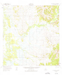
1952 Map of Holy Cross A-1
USGS Topo · Published 1976About this map
Reindeer River meanders through this interior Alaskan landscape, connecting a network of waterways and wetlands including the expansive Reindeer Lake. Photogrammetric methods from 1951 and 1952 reveal a complex system of drainage and relief, where Paimiut Slough marks the low-lying western edge of the quadrangle. The topography is defined by significant elevations such as Saddle Mountain and the surrounding Hills, which contrast with the saturated marshlands below.
Find a feature on this map
6 named features on this map. Tap any name to fly to it.
Don’t see what you’re looking for? This feature index may not catch every label — zoom into the map to look around manually.
Map Details
Editions of this 1952 Holy Cross A-1 Map
3 editions found

Other maps of this area

1947 · Russian Mission
USGS Topo · 1:250,000

1950 · Russian Mission
USGS Topo · 1:250,000

1950 · Sleetmute
USGS Topo · 1:250,000

1951 · Holy Cross
USGS Topo · 1:250,000

1951 · Iditarod
USGS Topo · 1:250,000

1952 · Holy Cross B-2
USGS Topo · 1:63,360

1952 · Holy Cross A-2
USGS Topo · 1:63,360

1952 · Holy Cross A-1
USGS Topo · 1:63,360

1952 · Holy Cross B-1
USGS Topo · 1:63,360

1952 · Russian Mission D-2
USGS Topo · 1:63,360