
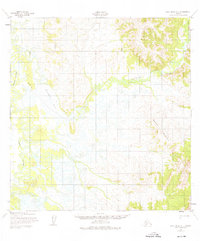
1952 Map of Holy Cross A-1
USGS Topo · Published 1981About this map
The low-lying wetlands of the Yukon-Koyukuk region are defined by an intricate network of waterways, centered on the expansive Reindeer Lake. Photogrammetric methods used by the Army Map Service in the early 1950s reveal a landscape dominated by the winding path of the Reindeer River and the complex channels of Paimiut Slough. This environment transitions abruptly to higher ground in the east, where the prominent relief of Saddle Mountain rises above the marshy flats.
Find a feature on this map
8 named features on this map. Tap any name to fly to it.
Don’t see what you’re looking for? This feature index may not catch every label — zoom into the map to look around manually.
Map Details
Editions of this 1952 Holy Cross A-1 Map
3 editions found
Other maps of this area

1947 · Russian Mission
USGS Topo · 1:250,000

1950 · Russian Mission
USGS Topo · 1:250,000

1950 · Sleetmute
USGS Topo · 1:250,000

1951 · Holy Cross
USGS Topo · 1:250,000

1951 · Iditarod
USGS Topo · 1:250,000

1952 · Holy Cross B-2
USGS Topo · 1:63,360

1952 · Holy Cross A-2
USGS Topo · 1:63,360

1952 · Holy Cross A-1
USGS Topo · 1:63,360

1952 · Holy Cross B-1
USGS Topo · 1:63,360

1952 · Russian Mission D-2
USGS Topo · 1:63,360