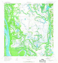
1952 Map of Holy Cross B-2
USGS Topo · Published 1967About this map
The Yukon River and Innoko River dominate this early 1950s landscape, weaving a complex web of sloughs, marshes, and oxbows through the Alaskan interior. This era of surveying shows the region's reliance on seasonal transit, most clearly indicated by the Winter Trail (Approximate) that cuts across the western bottomlands. Small signs of human habitation are rare, consisting of isolated structures like the Travis Cabins and a lone Cabin positioned near the riverbanks, suggesting temporary camps or seasonal dwellings for hunting or trapping. Notable water features like Horseshoe Lake and the large Carlo Island illustrate the shifting nature of these massive river systems. The absence of roads and the prevalence of wetlands highlight the remote character of the territory during this post-war mapping period, reflecting the landscape as it existed before significant modern alterations.
Find a feature on this map
7 named features on this map. Tap any name to fly to it.
Don’t see what you’re looking for? This feature index may not catch every label — zoom into the map to look around manually.
Map Details
Editions of this 1952 Holy Cross B-2 Map
2 editions found
Other maps of this area

1951 · Holy Cross
USGS Topo · 1:250,000

1952 · Holy Cross B-2
USGS Topo · 1:63,360

1952 · Holy Cross A-2
USGS Topo · 1:63,360

1952 · Holy Cross C-2
USGS Topo · 1:63,360

1952 · Holy Cross C-1
USGS Topo · 1:63,360

1952 · Holy Cross A-1
USGS Topo · 1:63,360

1952 · Holy Cross B-3
USGS Topo · 1:63,360

1952 · Holy Cross B-1
USGS Topo · 1:63,360

1952 · Holy Cross C-3
USGS Topo · 1:63,360

1952 · Holy Cross A-3
USGS Topo · 1:63,360