
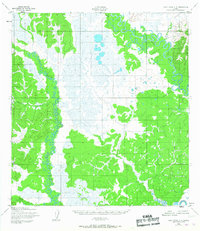
1952 Map of Holy Cross C-4
USGS Topo · Published 1959About this map
The confluence of intricate river systems dominates this mid-century topographic study of the Yukon-Koyukuk region. The Anvik River and Bonasila River snake through a landscape defined by extensive wetlands and complex drainage patterns, with the latter river winding significantly through the western and southern sectors of the map. Smaller tributaries like Stanstrom Creek and Goblet Creek feed into these major arteries, illustrating the hydrologic character of the Alaskan interior before modern infrastructure arrived. At the time of this survey, the area was notable for its lack of roads or trails, as indicated by the marginal notes, leaving the natural waterways as the primary landmarks. The terrain is characterized by numerous small lakes and marshy basins that separate the winding courses of Roberts Creek and the Hawk River.
Find a feature on this map
6 named features on this map. Tap any name to fly to it.
Don’t see what you’re looking for? This feature index may not catch every label — zoom into the map to look around manually.
Map Details
Editions of this 1952 Holy Cross C-4 Map
2 editions found
Other maps of this area

1951 · Holy Cross
USGS Topo · 1:250,000

1952 · Holy Cross C-5
USGS Topo · 1:63,360

1952 · Holy Cross D-5
USGS Topo · 1:63,360

1952 · Holy Cross D-4
USGS Topo · 1:63,360

1952 · Holy Cross B-3
USGS Topo · 1:63,360

1952 · Holy Cross D-3
USGS Topo · 1:63,360

1952 · Holy Cross B-5
USGS Topo · 1:63,360

1952 · Holy Cross C-3
USGS Topo · 1:63,360

1952 · Holy Cross B-4
USGS Topo · 1:63,360

1952 · Holy Cross
USGS Topo · 1:250,000