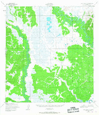
1952 Map of Holy Cross C-4
USGS Topo · Published 1967About this map
Bonasila River and the Anvik River dominate this interior Alaskan landscape, their complex meanders and oxbow lakes creating a dense network of waterways through the lowland terrain. Based on 1951 aerial photography with 1952 field annotations, the map reveals an unpopulated wilderness where the primary identifiers are the drainages themselves. The Anvik River winds through the eastern portion of the quadrangle, joined by Goblet Creek, while the western half is defined by the extensive reaches of the Bonasila River and its tributaries, Roberts Creek and the Hawk River. To the north, Theodore Cr marks the edge of a distinct wetland system. This document is notable for its lack of established roads or trails, reflecting a time when travel in this region was almost entirely dependent on these seasonal watercourses and the surrounding tundra.
Find a feature on this map
9 named features on this map. Tap any name to fly to it.
Don’t see what you’re looking for? This feature index may not catch every label — zoom into the map to look around manually.
Map Details
Editions of this 1952 Holy Cross C-4 Map
2 editions found
Other maps of this area

1951 · Holy Cross
USGS Topo · 1:250,000

1952 · Holy Cross C-5
USGS Topo · 1:63,360

1952 · Holy Cross D-5
USGS Topo · 1:63,360

1952 · Holy Cross D-4
USGS Topo · 1:63,360

1952 · Holy Cross B-3
USGS Topo · 1:63,360

1952 · Holy Cross D-3
USGS Topo · 1:63,360

1952 · Holy Cross B-5
USGS Topo · 1:63,360

1952 · Holy Cross C-3
USGS Topo · 1:63,360

1952 · Holy Cross C-4
USGS Topo · 1:63,360

1952 · Holy Cross B-4
USGS Topo · 1:63,360