1900s (20th Century) Maps of Kotlik, Alaska
Explore 4 historic maps of Kotlik from the 1900s (20th Century). These maps offer a rare glimpse into what life looked like during the 1900s — showing old roads, neighborhoods, homes, and landmarks that have changed or disappeared over time.
Whether you're researching your family's past, planning a metal detecting trip, or studying how Kotlik's landscape evolved across the 1900s, these high-resolution maps are a powerful tool for exploring the history of this region.
- Focus on a specific era: All maps on this page are from the 1900s, giving you a focused view of this time period.
- See what’s changed: Compare century-old streets, trails, and buildings to today's modern landscape using overlays and satellite layers.
- Research with precision: Use these maps for genealogy, historical research, land use analysis, or educational projects.
- View, download, or print: Maps are fully viewable online in high resolution, and can be downloaded or printed for your own records.
Start exploring Kotlik's history through authentic maps from the 1900s. This is your window into the past.
Kotlik, AK maps
(4)- 1951 Map of St Michael
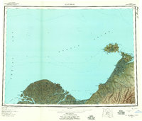
 1951 St Michael1951 Print · USGSCoastal Alaska at the mid-century reveals a world of remote outposts and intricate delta waterways. Researchers can trace the riverine geography of Kotlik, the settlement at St Michael, and traditional sites like Pastolik or Chaniliut along Norton Sound.
 - 1952 Map of Saint Michael A-4, 1958 Print
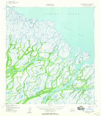 1952 Saint Michael A-41958 Print · USGSThe Yukon Delta coast meets the sea in the early 1950s, revealing a complex network of tidewater channels and river passes. Researchers can locate the settlement of Kotlik, several isolated cabins, and the inland Winter Trail cutting through the delta.2 unique versions available
 - 1952 Map of St Michael, 1959 Print
 1952 St Michael1959 Print · USGSThe northern Yukon-Kuskokwim Delta meets the sea in the early fifties, documenting a landscape of coastal villages and complex river passes. Researchers can trace the ancestral locations of Kotlik, Stebbins, and Nokogamiut alongside the historic ST MICHAEL TRAIL.4 unique versions available
 - 1964 Map of St. Michael
 1964 St. Michael1964 Print · USGSCoastal settlements and the vast Yukon Delta waterways are charted here during the mid-1960s. Genealogists and historians can trace the locations of traditional villages like Kotlik, Nunaktuk, and Chaniliut along the Apoon Mouth.
End of results
Showing maps 1-4 of 4
Frequently asked questions
- What are the different types of historical maps available for Kotlik?
- What is the oldest map of Kotlik?
- Where can I purchase historical maps of Kotlik for my home or office?
- Where can I download high-res historical maps of Kotlik?
- Are there historical topographic maps available for Kotlik?
- Is there historical aerial imagery available for Kotlik?
- Where are historical maps of Kotlik sourced from?