Old Maps of Kougarok, Alaska for Metal Detecting
Plan your next treasure hunt with 5 historic maps of Kougarok. Find old homesites, ghost towns, trails, and gathering spots that may be lost to time — perfect for identifying promising metal detecting locations.
- Locate forgotten sites: Uncover places like long-lost settlements, abandoned rail lines, or gathering spots.
- Plan better hunts: Use map overlays combined with LiDAR or satellite views to narrow in on historically rich areas.
- Made for detectorists: Thousands of hobbyists use these maps to discover relics, coins, and hidden history.
Use these historic maps to boost your research and find new opportunities beneath the surface of Kougarok.
Kougarok, AK maps
(5)- 1950 Map of Bendeleben B-6, 1955 Print
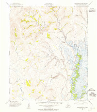 1950 Bendeleben B-61955 Print · USGSThe Kougarok River valley in 1950 was a hub of Alaskan gold mining and wilderness aviation. Researchers can trace the development of Placer Gold Mining Areas near Dahl, early landing strips, and the network of Tractor Trails connecting the remote interior.3 unique versions available
 - 1950 Map of Bendeleben, 1956 Print
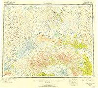 1950 Bendeleben1956 Print · USGSThe Seward Peninsula in the early fifties shows a rugged interior reliant on aviation and gold mining. Researchers can trace remote outposts like Bunker Hill Station and Aurora or find landing strips at Utica Landing Area.6 unique versions available
 - 1951 Map of Bendeleben
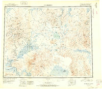 1951 Bendeleben1951 Print · USGSThe central Seward Peninsula in the early fifties was a rugged frontier of isolated mining outposts and volcanic fields. Researchers can trace the path of the Railroad (Abandoned) and locate early settlements like Noxapaga, Aurora, and Shelton.2 unique versions available
 - 1964 Map of Bendeleben
 1964 Bendeleben1964 Print · USGSThe central Seward Peninsula comes into focus in the 1950s, showing a landscape of volcanic cones, river systems, and mining outposts. Trace the history of remote settlements like Taylor and Dahl or locate seasonal cabins near Imuruk Lake and Death Valley.
 - 2017 Map of Bendeleben B-6 SE, 2017 Print
 2017 Bendeleben B-6 SE2017 Print · USGSThe Seward Peninsula interior comes into focus during the mid-2010s, showing the intersection of remote highway transit and the Kougarok River basin. Trace the route of the Kougarok Road past the settlement of Dahl and the slopes of Coffee Dome.
End of results
Showing maps 1-5 of 5
Frequently asked questions
- What are the different types of historical maps available for Kougarok?
- What is the oldest map of Kougarok?
- Where can I purchase historical maps of Kougarok for my home or office?
- Where can I download high-res historical maps of Kougarok?
- Are there historical topographic maps available for Kougarok?
- Is there historical aerial imagery available for Kougarok?
- Where are historical maps of Kougarok sourced from?