Old Maps of Kwigillingok, Alaska for Academic Research
Study the evolution of Kwigillingok with 4 high-resolution historic maps. Whether you're teaching, researching, or modeling changes in land use, these maps provide essential visual documentation of urban, environmental, and geographic change.
- Analyze long-term change: Track patterns in development, transportation, and natural features.
- Ideal for environmental or urban studies: Support academic projects with primary historical map data.
- Use in the classroom or lab: Educators and researchers rely on these maps to bring historical context to life.
These maps are a powerful tool for teaching, research, and visualizing how Kwigillingok has changed over the decades.
Kwigillingok, AK maps
(4)- 1951 Map of Kuskokwim Bay
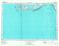
 1951 Kuskokwim Bay1951 Print · USGSThe coastal margins of the Bering Sea in the mid-century reveal a world of isolated settlements and river mouths. Researchers can trace the layout of Kwinhagak, Kipnuk, and Kongiganak along the reaches of Kuskokwim Bay and the Kanektok River.
 - 1954 Map of Kuskokwim Bay, 1967 Print
 1954 Kuskokwim Bay1967 Print · USGSCoastal life in western Alaska during the mid-fifties centered on river mouths and tundra lakes. Researchers can trace remote settlements like Kipnuk and Kongiganak or locate the Seaplane Anchorage used for essential regional transit.3 unique versions available
 - 1954 Map of Kuskokwim Bay D-4, 1971 Print
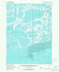 1954 Kuskokwim Bay D-41971 Print · USGSCoastal Alaska at the edge of the Bering Sea reveals a labyrinth of tidal mudflats and tundra lakes in the mid-fifties. Researchers can locate the settlement of Kwigillingok and trace the winding course of the Kwigillingok River near Anogok.2 unique versions available
 - 2020 Map of Kuskokwim Bay D-4 NE, 2020 Print
 2020 Kuskokwim Bay D-4 NE2020 Print · USGSThe coastal wetlands of the Bethel Census Area appear in high detail during the early 2020s. Researchers can trace the remote settlement of Kwigillingok and its connection to the Kolekfikpuk Lake and Kwigillingok River transport corridors.
End of results
Showing maps 1-4 of 4
Frequently asked questions
- What are the different types of historical maps available for Kwigillingok?
- What is the oldest map of Kwigillingok?
- Where can I purchase historical maps of Kwigillingok for my home or office?
- Where can I download high-res historical maps of Kwigillingok?
- Are there historical topographic maps available for Kwigillingok?
- Is there historical aerial imagery available for Kwigillingok?
- Where are historical maps of Kwigillingok sourced from?