Old Maps of Lake Minchumina, Alaska for Academic Research
Study the evolution of Lake Minchumina with 7 high-resolution historic maps. Whether you're teaching, researching, or modeling changes in land use, these maps provide essential visual documentation of urban, environmental, and geographic change.
- Analyze long-term change: Track patterns in development, transportation, and natural features.
- Ideal for environmental or urban studies: Support academic projects with primary historical map data.
- Use in the classroom or lab: Educators and researchers rely on these maps to bring historical context to life.
These maps are a powerful tool for teaching, research, and visualizing how Lake Minchumina has changed over the decades.
Lake Minchumina, AK maps
(7)- 1952 Map of Mount McKinley
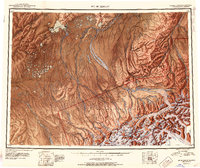 1952 Mount McKinley1952 Print · USGSInterior Alaska in the early fifties shows a landscape of massive glaciers and remote mining outposts. Researchers can trace the legacy of the Stampede Antimony Mine, locate the isolated settlement of Kantishna, and follow the historic Sled Road through the high country.4 unique versions available
 - 1953 Map of Mount McKinley D-5, 1965 Print
 1953 Mount McKinley D-51965 Print · USGSThe Alaskan interior at the geographic center of the state was a landscape of remote river systems and isolated outposts in the early fifties. Researchers can locate the Geographic Center of Alaska and trace early aviation routes at the Lake Minchumina Landing Area.2 unique versions available
 - 1954 Map of Mount McKinley D-5, 1956 Print
 1954 Mount McKinley D-51956 Print · USGSThe Lake Minchumina region in the mid-1950s was a vital interior Alaska crossroads shaped by winter trails and small bush planes. Researchers can trace the early Sled Road network and locate isolated wilderness Cabins near the Foraker River.
 - 1958 Map of Mount McKinley, 1966 Print
 1958 Mount McKinley1966 Print · USGSDenali's towering peaks and the surrounding subarctic wilderness are captured here in the mid-fifties, before the park's later expansion. You can trace early park outposts like Toklat Ranger Sta, the remote settlement at Kantishna, and the isolated Busia Cabin near Wonder Lake.3 unique versions available
 - 1969 Map of Mount McKinley, 1970 Print
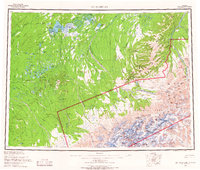
 1969 Mount McKinley1970 Print · USGSThe interior Alaska wilderness appears in the late 1960s, centered on the heights of the Alaska Range and the remote river drainages. Researchers can trace the Winter Trail networks and find early outposts like Kantishna and the Toklat Ranger Sta.
 - 2017 Map of Denali D-5 NW, 2017 Print
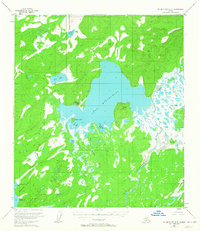
 2017 Denali D-5 NW2017 Print · USGSCovers Lake Minchumina, including Unorganized Borough, United States, and other nearby areas
 - 2023 Map of Denali D-5 NW, 2023 Print
 2023 Denali D-5 NW2023 Print · USGSThe Lake Minchumina area in the early 2020s serves as a remote crossroads where wilderness aviation meets the water. Researchers can trace the layout of the Minchumina Airport and surrounding water bodies like Jim Lake and Williams Lake.
End of results
Showing maps 1-7 of 7
Frequently asked questions
- What are the different types of historical maps available for Lake Minchumina?
- What is the oldest map of Lake Minchumina?
- Where can I purchase historical maps of Lake Minchumina for my home or office?
- Where can I download high-res historical maps of Lake Minchumina?
- Are there historical topographic maps available for Lake Minchumina?
- Is there historical aerial imagery available for Lake Minchumina?
- Where are historical maps of Lake Minchumina sourced from?