Old Maps of Lees Camp, Alaska for Hiking & Exploration
Hike through history with 5 historic maps of Lees Camp. Explore old trails, ghost towns, and forgotten backroads — perfect for outdoor adventurers and local explorers.
- Rediscover forgotten places: Map out old mining camps, roads, and footpaths that no longer exist on modern maps.
- Layer with modern tools: Combine with LiDAR or satellite views to plan hikes through historical terrain.
- Made for exploration: Popular among hikers, overlanders, and local history lovers.
Use these maps to find adventure and explore the hidden past of Lees Camp.
Lees Camp, AK maps
(5)- 1907 Map of Solomon
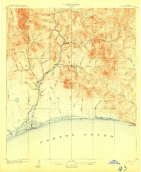 1907 Solomon1907 Print · USGSCoastal Alaska during the gold rush era reveals a landscape of rapid industrialization along the Norton Sound. You can trace the Council City and Solomon River RR from Solomon up to the Big Hurrah Mine and find numerous gold-bearing gulches.2 unique versions available
 - 1950 Map of Solomon C-5, 1956 Print
 1950 Solomon C-51956 Print · USGSThe Seward Peninsula coastline comes alive in this mid-century survey of the Solomon River corridor and its mining interior. Researchers can trace the Solomon Railroad Grade, locate the Big Hurrah Mine, and explore remote sites like Quigleys Camp.3 unique versions available
 - 1950 Map of Solomon, 1956 Print
 1950 Solomon1956 Print · USGSThe southern Seward Peninsula is captured here in the mid-1950s, showing a landscape defined by coastal outposts and inland mining camps. Trace historic routes like the Winter Trail or locate the Big Hurrah Mine and Ruby Roadhouse.5 unique versions available
 - 1951 Map of Solomon
 1951 Solomon1951 Print · USGSThe Seward Peninsula during the mid-century shows the intricate network of mining trails and coastal outposts that followed the gold rushes. Researchers can trace the Seward Peninsula Railroad and locate interior settlements like Council or the Big Hurrah Mine.3 unique versions available
 - 2018 Map of Solomon C-5 SW, 2018 Print
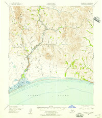
 2018 Solomon C-5 SW2018 Print · USGSCoastal Alaska on the Seward Peninsula is mapped here in the late 2010s, showing the intersection of the Council Road and the Bering Sea. You can trace the historic settlement at Solomon and the remote airfield at Solomon State Field near the mouth of the Solomon River.
End of results
Showing maps 1-5 of 5
Frequently asked questions
- What are the different types of historical maps available for Lees Camp?
- What is the oldest map of Lees Camp?
- Where can I purchase historical maps of Lees Camp for my home or office?
- Where can I download high-res historical maps of Lees Camp?
- Are there historical topographic maps available for Lees Camp?
- Is there historical aerial imagery available for Lees Camp?
- Where are historical maps of Lees Camp sourced from?