
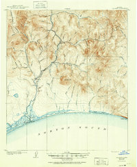
1907 Map of Solomon
USGS Topo · Published 1907About this map
Solomon and the neighboring settlement of Dickson anchor this coastal survey at the mouth of the Solomon River along the Norton Sound. At the height of the Seward Peninsula gold rush, the landscape was heavily defined by extractive industries and the infrastructure built to support them. The Council City and Solomon River RR tracks northward from the coast, following the river valley through a territory dense with gold-bearing tributaries such as Shovel Creek and Coarse Gold Gl.
Find a feature on this map
87 named features on this map. Tap any name to fly to it.
Don’t see what you’re looking for? This feature index may not catch every label — zoom into the map to look around manually.
Map Details
Editions of this 1907 Solomon Map
2 editions found
Other maps of this area

1907 · Casadepaga
USGS Topo · 1:62,500

1950 · Solomon C-5
USGS Topo · 1:63,360

1950 · Solomon C-6
USGS Topo · 1:63,360

1950 · Solomon C-4
USGS Topo · 1:63,360

1950 · Solomon B-6
USGS Topo · 1:63,360

1950 · Solomon
USGS Topo · 1:250,000

1950 · Solomon D-6
USGS Topo · 1:63,360

1950 · Solomon D-4
USGS Topo · 1:63,360

1950 · Solomon D-5
USGS Topo · 1:63,360

1951 · Solomon
USGS Topo · 1:250,000