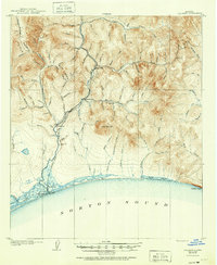
1907 Map of Solomon
USGS Topo · Published 1951About this map
Gold mining operations and early Alaskan transport networks dominate this 1905 survey of the Seward Peninsula shoreline. The Solomon River serves as the primary corridor for settlement and industry, with the coastal towns of Solomon and Dickson established at its mouth on Norton Sound. Moving inland, the Council City and Solomon River railroad tracks follow the river's path, providing critical access to interior claims.
Find a feature on this map
85 named features on this map. Tap any name to fly to it.
Don’t see what you’re looking for? This feature index may not catch every label — zoom into the map to look around manually.
Map Details
Editions of this 1907 Solomon Map
2 editions found
Other maps of this area

1907 · Casadepaga
USGS Topo · 1:62,500

1907 · Solomon
USGS Topo · 1:62,500

1950 · Solomon C-5
USGS Topo · 1:63,360

1950 · Solomon C-6
USGS Topo · 1:63,360

1950 · Solomon C-4
USGS Topo · 1:63,360

1950 · Solomon B-6
USGS Topo · 1:63,360

1950 · Solomon
USGS Topo · 1:250,000

1950 · Solomon D-6
USGS Topo · 1:63,360

1950 · Solomon D-4
USGS Topo · 1:63,360

1950 · Solomon D-5
USGS Topo · 1:63,360