1900s (20th Century) Maps of Medfra, Alaska
Explore 3 historic maps of Medfra from the 1900s (20th Century). These maps offer a rare glimpse into what life looked like during the 1900s — showing old roads, neighborhoods, homes, and landmarks that have changed or disappeared over time.
Whether you're researching your family's past, planning a metal detecting trip, or studying how Medfra's landscape evolved across the 1900s, these high-resolution maps are a powerful tool for exploring the history of this region.
- Focus on a specific era: All maps on this page are from the 1900s, giving you a focused view of this time period.
- See what’s changed: Compare century-old streets, trails, and buildings to today's modern landscape using overlays and satellite layers.
- Research with precision: Use these maps for genealogy, historical research, land use analysis, or educational projects.
- View, download, or print: Maps are fully viewable online in high resolution, and can be downloaded or printed for your own records.
Start exploring Medfra's history through authentic maps from the 1900s. This is your window into the past.
Medfra, AK maps
(3)- 1950 Map of Medfra
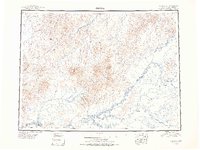 1950 Medfra1950 Print · USGSThe Alaskan interior in the mid-twentieth century was a land of river navigation and seasonal trails. You can trace the routes between the Slow Fork Roadhouse, the Nixon Fork Mine, and the river settlement at Medfra.2 unique versions available
 - 1959 Map of Medfra A-4, 1964 Print
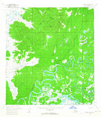 1959 Medfra A-41964 Print · USGSMedfra sits along the winding Kuskokwim River during the late 1950s, serving as a remote outpost in the Alaskan interior. Researchers can trace the river's complex oxbows and find vital bush infrastructure like the Airstrip, the Winter Trail, and Medfra itself.2 unique versions available
 - 1959 Map of Medfra, 1967 Print
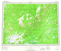 1959 Medfra1967 Print · USGSThe Alaskan interior comes into focus during the late fifties, centered on the riverine life of the Kuskokwim River basin. Researchers can trace the path of the Winter Trail, locate the remote landing at Medfra, and survey the heights of the Sischu Mountains.3 unique versions available
End of results
Showing maps 1-3 of 3
Frequently asked questions
- What are the different types of historical maps available for Medfra?
- What is the oldest map of Medfra?
- Where can I purchase historical maps of Medfra for my home or office?
- Where can I download high-res historical maps of Medfra?
- Are there historical topographic maps available for Medfra?
- Is there historical aerial imagery available for Medfra?
- Where are historical maps of Medfra sourced from?