Old Maps of New Knockhock, Alaska for Genealogy
Trace your family roots with 3 historic maps of New Knockhock. These high-res maps reveal old neighborhoods, homesites, landmarks, and streets — helping you uncover where your ancestors lived and how the area evolved over time.
- Explore historic neighborhoods: Identify where your relatives may have lived in the 1800s or 1900s.
- Compare maps over time: Trace the changes in streets, buildings, and landmarks for multi-generational research.
- Perfect for genealogy & ancestry research: Used by family historians and researchers to map out lineage and migration.
These maps are an incredible resource for exploring your personal connection to New Knockhock's past.
New Knockhock, AK maps
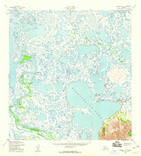
(3)- 1952 Map of Kwiguk
 1952 Kwiguk1952 Print · USGSThe Yukon Delta in the early fifties was a vast network of seasonal waterways and remote outposts. Researchers can trace the Winter Trail past Bill Moores or locate historic river settlements like New Fort Hamilton and Akulurak P O.8 unique versions available
 - 1952 Map of Kwiguk A-6, 1959 Print
 1952 Kwiguk A-61959 Print · USGSThe Yukon-Kuskokwim Delta's vast water-and-tundra landscape is detailed in this mid-century survey. Trace the winding course of the Black River and the expansive shoreline of Nunavakanuk Lake toward the Kuzitak Mountains.2 unique versions available
 - 2020 Map of Kwiguk A-6 NW, 2020 Print
 2020 Kwiguk A-6 NW2020 Print · USGSThe Yukon Delta comes into focus in this recent survey of the Kusilvak region. Genealogists and researchers can trace the movement of the Black River and locate the settlement of New Knockhock near the southern reaches of Anakshek Pass.
End of results
Showing maps 1-3 of 3
Frequently asked questions
- What are the different types of historical maps available for New Knockhock?
- What is the oldest map of New Knockhock?
- Where can I purchase historical maps of New Knockhock for my home or office?
- Where can I download high-res historical maps of New Knockhock?
- Are there historical topographic maps available for New Knockhock?
- Is there historical aerial imagery available for New Knockhock?
- Where are historical maps of New Knockhock sourced from?