Old Maps of Nunam Iqua, Alaska for Academic Research
Study the evolution of Nunam Iqua with 5 high-resolution historic maps. Whether you're teaching, researching, or modeling changes in land use, these maps provide essential visual documentation of urban, environmental, and geographic change.
- Analyze long-term change: Track patterns in development, transportation, and natural features.
- Ideal for environmental or urban studies: Support academic projects with primary historical map data.
- Use in the classroom or lab: Educators and researchers rely on these maps to bring historical context to life.
These maps are a powerful tool for teaching, research, and visualizing how Nunam Iqua has changed over the decades.
Nunam Iqua, AK maps
(5)- 1952 Map of Kwiguk
 1952 Kwiguk1952 Print · USGSThe Yukon Delta in the early fifties was a vast network of seasonal waterways and remote outposts. Researchers can trace the Winter Trail past Bill Moores or locate historic river settlements like New Fort Hamilton and Akulurak P O.8 unique versions available
 - 1952 Map of Kwiguk C-6, 1959 Print
 1952 Kwiguk C-61959 Print · USGSThe Yukon-Kuskokwim Delta in the early fifties was a labyrinth of vital waterways and small outposts. Genealogists and researchers can trace the seasonal movements and settlements of the era through labels like Alakanuk, Akulurak, and the Winter Trail.3 unique versions available
 - 1952 Map of Kwiguk B-6, 1959 Print
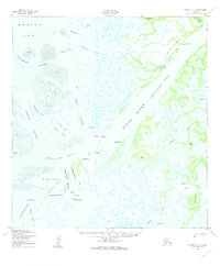
 1952 Kwiguk B-61959 Print · USGSThe coastal tundra of western Alaska is captured here in the early fifties, showing a complex world of tidal passes and seasonal trails. Trace the Winter Trail past Eleutak and navigate the reaches of Kwemeluk Pass and Black River.2 unique versions available
 - 2020 Map of Kwiguk C-6 SW, 2020 Print
 2020 Kwiguk C-6 SW2020 Print · USGSThe Yukon River delta near the Bering Sea coast is captured here in detail as it appeared in 2020. Local historians and genealogists can trace the footprint of Nunam Iqua and Sheldon Point or locate the Nunam Iqua Airport and Nililak among the sloughs.
 - 2020 Map of Kwiguk B-6 NW, 2020 Print
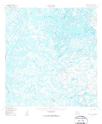
 2020 Kwiguk B-6 NW2020 Print · USGSNunam Iqua and the surrounding Yukon Delta wetlands are captured here in the early twenty-first century. Researchers can trace the winding paths of the Kanyak River, the Nagasakchowik Slough, and Kwemeluk Pass through this watery landscape.
End of results
Showing maps 1-5 of 5
Top cities near Nunam Iqua
Frequently asked questions
- What are the different types of historical maps available for Nunam Iqua?
- What is the oldest map of Nunam Iqua?
- Where can I purchase historical maps of Nunam Iqua for my home or office?
- Where can I download high-res historical maps of Nunam Iqua?
- Are there historical topographic maps available for Nunam Iqua?
- Is there historical aerial imagery available for Nunam Iqua?
- Where are historical maps of Nunam Iqua sourced from?