
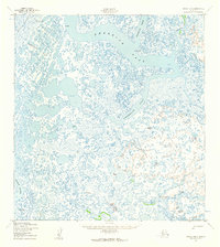
1952 Map of Kwiguk B-6
USGS Topo · Published 1959About this map
Kwemeluk Pass and Kanelik Pass dominate this 1950s hydrographic landscape, where a dense network of sloughs and interconnected waterways defines the coastal tundra of western Alaska. The small settlement of Eleutak sits along the northern edge of the sheet, serving as a primary human landmark in a region characterized by shifting waters and seasonal migration routes. The presence of the Winter Trail (Approximate) cutting through the landscape highlights the critical importance of overland travel during the frozen months when the intricate river systems become solid thoroughfares.
Find a feature on this map
16 named features on this map. Tap any name to fly to it.
Don’t see what you’re looking for? This feature index may not catch every label — zoom into the map to look around manually.
Map Details
Editions of this 1952 Kwiguk B-6 Map
2 editions found
Other maps of this area

1951 · Black
USGS Topo · 1:250,000

1952 · Kwiguk
USGS Topo · 1:250,000
1952 · Black C-1
USGS Topo · 1:63,360

1952 · Black A-1
USGS Topo · 1:63,360

1952 · Black B-1
USGS Topo · 1:63,360

1952 · Kwiguk A-5
USGS Topo · 1:63,360

1952 · Kwiguk C-6
USGS Topo · 1:63,360

1952 · Kwiguk A-6
USGS Topo · 1:63,360

1952 · Kwiguk B-5
USGS Topo · 1:63,360

1952 · Kwiguk C-5
USGS Topo · 1:63,360