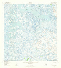
1952 Map of Kwiguk B-6
USGS Topo · Published 1959About this map
Eleutak stands as the primary named settlement on this 1952 topographic survey, situated within a complex delta environment where the Black River and Ponglevik River meet the Bering Sea's tidal influences. The landscape is defined by an intricate network of waterways, including the broad Kwemeluk Pass and the winding Anakshek Pass. A Winter Trail cuts across the northern reaches, indicating the seasonal transport patterns necessary for navigating this watery terrain. Surveyed just after the war by the Army Map Service, the map records numerous sloughs such as Nagakchowik Slough and Lookout Slough, which served as vital corridors for local movement through the vast wetlands. Three triangulation stations, including VABM Kwemeluk, provide fixed navigation points in an otherwise shifting landscape of marshes and river channels.
Find a feature on this map
14 named features on this map. Tap any name to fly to it.
Don’t see what you’re looking for? This feature index may not catch every label — zoom into the map to look around manually.
Map Details
Editions of this 1952 Kwiguk B-6 Map
2 editions found
Other maps of this area

1951 · Black
USGS Topo · 1:250,000

1952 · Kwiguk
USGS Topo · 1:250,000
1952 · Black C-1
USGS Topo · 1:63,360

1952 · Black A-1
USGS Topo · 1:63,360

1952 · Black B-1
USGS Topo · 1:63,360

1952 · Kwiguk A-5
USGS Topo · 1:63,360

1952 · Kwiguk C-6
USGS Topo · 1:63,360

1952 · Kwiguk B-6
USGS Topo · 1:63,360

1952 · Kwiguk A-6
USGS Topo · 1:63,360

1952 · Kwiguk B-5
USGS Topo · 1:63,360