Old Maps of Old Rampart, Alaska for Hiking & Exploration
Hike through history with 4 historic maps of Old Rampart. Explore old trails, ghost towns, and forgotten backroads — perfect for outdoor adventurers and local explorers.
- Rediscover forgotten places: Map out old mining camps, roads, and footpaths that no longer exist on modern maps.
- Layer with modern tools: Combine with LiDAR or satellite views to plan hikes through historical terrain.
- Made for exploration: Popular among hikers, overlanders, and local history lovers.
Use these maps to find adventure and explore the hidden past of Old Rampart.
Old Rampart, AK maps
(4)- 1951 Map of Coleen, 1952 Print
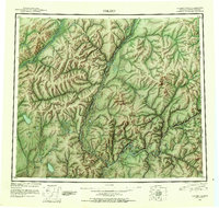 1951 Coleen1952 Print · USGSThe northern interior of Alaska meets the Yukon border in the early fifties, showing a land still defined by its major rivers. Researchers can trace the isolated outposts at Old Rampart and Owens Cabins along the banks of the Porcupine River.4 unique versions available
 - 1956 Map of Coleen
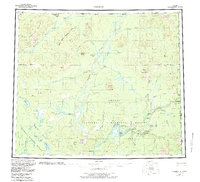 1956 Coleen1956 Print · USGSNortheastern Alaska's vast river systems are documented here during the mid-century expansion of the national refuge system. Researchers can locate remote outposts like Old Rampart, navigate the Coleen River, and trace the primitive Tractor Trail.9 unique versions available
 - 1956 Map of Coleen A-2, 1959 Print
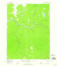 1956 Coleen A-21959 Print · USGSThe Porcupine River wilderness comes into focus in the mid-1950s, showing the remote confluence of two major northern rivers. Researchers can trace historic riverbank locations like Old Rampart and Old Camp or locate the distinct Howling Dog Rock.3 unique versions available
 - 2018 Map of Coleen A-2 NE, 2018 Print
 2018 Coleen A-2 NE2018 Print · USGSThe Porcupine River corridor near the Alaska-Canada border is captured here in the late 2010s. Local researchers can locate Old Rampart and trace the confluence of the Porcupine River and the Salmon Trout River.
End of results
Showing maps 1-4 of 4
Frequently asked questions
- What are the different types of historical maps available for Old Rampart?
- What is the oldest map of Old Rampart?
- Where can I purchase historical maps of Old Rampart for my home or office?
- Where can I download high-res historical maps of Old Rampart?
- Are there historical topographic maps available for Old Rampart?
- Is there historical aerial imagery available for Old Rampart?
- Where are historical maps of Old Rampart sourced from?