1900s (20th Century) Maps of Pilot Station, Alaska
Explore 3 historic maps of Pilot Station from the 1900s (20th Century). These maps offer a rare glimpse into what life looked like during the 1900s — showing old roads, neighborhoods, homes, and landmarks that have changed or disappeared over time.
Whether you're researching your family's past, planning a metal detecting trip, or studying how Pilot Station's landscape evolved across the 1900s, these high-resolution maps are a powerful tool for exploring the history of this region.
- Focus on a specific era: All maps on this page are from the 1900s, giving you a focused view of this time period.
- See what’s changed: Compare century-old streets, trails, and buildings to today's modern landscape using overlays and satellite layers.
- Research with precision: Use these maps for genealogy, historical research, land use analysis, or educational projects.
- View, download, or print: Maps are fully viewable online in high resolution, and can be downloaded or printed for your own records.
Start exploring Pilot Station's history through authentic maps from the 1900s. This is your window into the past.
Pilot Station, AK maps
(3)- 1951 Map of Marshall
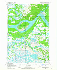
 1951 Marshall1951 Print · USGSThe Yukon River corridor and its surrounding delta wetlands are documented here in the early fifties, showcasing the vital riverine economy of the day. Researchers can trace remote settlements and points of interest like Pilot Station, Marshall, and Owl Village.
 - 1952 Map of Marshall D-3, 1964 Print
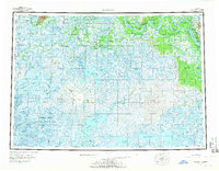
 1952 Marshall D-31964 Print · USGSThe lower Yukon delta in the early fifties was a realm of seasonal trails and vital river corridors centered around Pilot Station. Researchers can trace the braided paths of the Yukon River and locate remote routes like the Winter (Approximate) Trail.2 unique versions available
 - 1954 Map of Marshall, 1966 Print
 1954 Marshall1966 Print · USGSThe Yukon Delta and lower river system appear in intricate detail during the mid-fifties, showing the essential water routes and riverfront settlements of the era. Genealogists and researchers can locate Marshall (Fortuna Ledge PO), Pilot Station, and the seasonal Winter Trail crossing the frozen landscape.3 unique versions available
End of results
Showing maps 1-3 of 3
Top neighborhoods of Pilot Station
Frequently asked questions
- What are the different types of historical maps available for Pilot Station?
- What is the oldest map of Pilot Station?
- Where can I purchase historical maps of Pilot Station for my home or office?
- Where can I download high-res historical maps of Pilot Station?
- Are there historical topographic maps available for Pilot Station?
- Is there historical aerial imagery available for Pilot Station?
- Where are historical maps of Pilot Station sourced from?