Old Maps of Poorman, Alaska for Hiking & Exploration
Hike through history with 5 historic maps of Poorman. Explore old trails, ghost towns, and forgotten backroads — perfect for outdoor adventurers and local explorers.
- Rediscover forgotten places: Map out old mining camps, roads, and footpaths that no longer exist on modern maps.
- Layer with modern tools: Combine with LiDAR or satellite views to plan hikes through historical terrain.
- Made for exploration: Popular among hikers, overlanders, and local history lovers.
Use these maps to find adventure and explore the hidden past of Poorman.
Poorman, AK maps
(5)- 1951 Map of Ruby
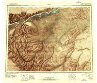 1951 Ruby1951 Print · USGSThe Yukon River interior comes to life in this mid-century study of the riverfront at Ruby and the surrounding gold-bearing creeks. Genealogists and historians can trace the seasonal routes of the Winter Trail, identify remote Placer Mines, and locate vanished sites like Placerville.2 unique versions available
 - 1952 Map of Ruby A-6, 1957 Print
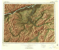
 1952 Ruby A-61957 Print · USGSThe Yukon-Koyukuk interior in the early fifties shows a landscape of remote mining outposts and seasonal transit routes. Researchers can trace the decline of early settlements like Placerville or locate mid-century activity at Poorman and the nearby Strip Mine.2 unique versions available
 - 1952 Map of Ruby, 1958 Print
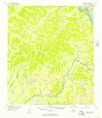
 1952 Ruby1958 Print · USGSThe Yukon River interior comes to life in the early fifties, showing the remote mining camps and river life of the region. Genealogists and researchers can trace the Telegraph Line and find historic sites like Poorman, Placerville, and Sulatna Crossing.8 unique versions available
 - 1964 Map of Ruby
 1964 Ruby1964 Print · USGSAlaska's interior river country and gold districts are shown here during the mid-1960s, centered on the Yukon River corridor. Researchers can trace historic mining activity and remote outposts like Poorman, Placerville, and the Kokrines Cem.
 - 2019 Map of Ruby A-6 SE, 2019 Print
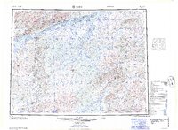
 2019 Ruby A-6 SE2019 Print · USGSThe interior Alaskan wilderness near the Ruby mining district is captured here during the late twenty-tens. Researchers can trace the path of the Ruby/Poorman Road (Extension) and locate the remote settlement of Poorman and nearby Tenderfoot Cr.
End of results
Showing maps 1-5 of 5
Frequently asked questions
- What are the different types of historical maps available for Poorman?
- What is the oldest map of Poorman?
- Where can I purchase historical maps of Poorman for my home or office?
- Where can I download high-res historical maps of Poorman?
- Are there historical topographic maps available for Poorman?
- Is there historical aerial imagery available for Poorman?
- Where are historical maps of Poorman sourced from?