Old Maps of Port Safety, Alaska for Hiking & Exploration
Hike through history with 4 historic maps of Port Safety. Explore old trails, ghost towns, and forgotten backroads — perfect for outdoor adventurers and local explorers.
- Rediscover forgotten places: Map out old mining camps, roads, and footpaths that no longer exist on modern maps.
- Layer with modern tools: Combine with LiDAR or satellite views to plan hikes through historical terrain.
- Made for exploration: Popular among hikers, overlanders, and local history lovers.
Use these maps to find adventure and explore the hidden past of Port Safety.
Port Safety, AK maps
(4)- 1950 Map of Solomon B-6, 1956 Print
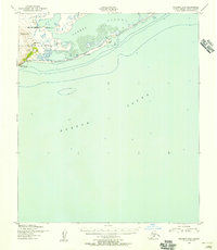 1950 Solomon B-61956 Print · USGSCoastal life on the Seward Peninsula in the 1950s centered around the narrow spit separating the open sea from protected waters. Trace the maritime history of this remote stretch through landmarks like the Port Safety Roadhouse, the Ferry, and Cape Nome.3 unique versions available
 - 1950 Map of Solomon, 1956 Print
 1950 Solomon1956 Print · USGSThe southern Seward Peninsula is captured here in the mid-1950s, showing a landscape defined by coastal outposts and inland mining camps. Trace historic routes like the Winter Trail or locate the Big Hurrah Mine and Ruby Roadhouse.5 unique versions available
 - 1951 Map of Solomon
 1951 Solomon1951 Print · USGSThe Seward Peninsula during the mid-century shows the intricate network of mining trails and coastal outposts that followed the gold rushes. Researchers can trace the Seward Peninsula Railroad and locate interior settlements like Council or the Big Hurrah Mine.3 unique versions available
 - 2017 Map of Solomon B-6 NW, 2017 Print
 2017 Solomon B-6 NW2017 Print · USGSThe southern coast of the Seward Peninsula comes into focus in this recent survey of the Bering Sea shoreline. Researchers can trace the path of Council Road across the lagoon at Port Safety and locate landmarks like Reindeer Hill and Cape Nome.
End of results
Showing maps 1-4 of 4
Frequently asked questions
- What are the different types of historical maps available for Port Safety?
- What is the oldest map of Port Safety?
- Where can I purchase historical maps of Port Safety for my home or office?
- Where can I download high-res historical maps of Port Safety?
- Are there historical topographic maps available for Port Safety?
- Is there historical aerial imagery available for Port Safety?
- Where are historical maps of Port Safety sourced from?