Old Maps of Scammon Bay, Alaska for Hiking & Exploration
Hike through history with 5 historic maps of Scammon Bay. Explore old trails, ghost towns, and forgotten backroads — perfect for outdoor adventurers and local explorers.
- Rediscover forgotten places: Map out old mining camps, roads, and footpaths that no longer exist on modern maps.
- Layer with modern tools: Combine with LiDAR or satellite views to plan hikes through historical terrain.
- Made for exploration: Popular among hikers, overlanders, and local history lovers.
Use these maps to find adventure and explore the hidden past of Scammon Bay.
Scammon Bay, AK maps
(5)- 1951 Map of Hooper Bay
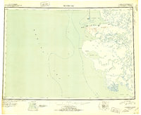 1951 Hooper Bay1951 Print · USGSThe Yukon-Kuskokwim Delta coast is captured here just after the war, showing the remote settlements and river systems of the Bering Sea. You can trace the Winter Trail between Scammon Bay and Kutmiut or locate the old landing at Hooper Bay.
 - 1952 Map of Hooper Bay D-2, 1965 Print
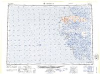
 1952 Hooper Bay D-21965 Print · USGSThe Yukon-Kuskokwim Delta coastline is captured here in the early fifties, showing the remote settlement of Scammon Bay. Researchers can trace the Winter Trail across the marshes or locate Castle Hill and Igayarok Pass.2 unique versions available
 - 1953 Map of Hooper Bay, 1963 Print
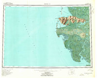 1953 Hooper Bay1963 Print · USGSThe Bering Sea coast near the Yukon-Kuskokwim Delta appears here in the early fifties, showing a land of tidal rivers and tundra. Trace the locations of Hooper Bay, Chevak, and Old Chevak alongside the prominent As Kinuk Mountains.5 unique versions available
 - 1964 Map of Hooper Bay
 1964 Hooper Bay1964 Print · USGSCoastal Alaska's Yukon-Kuskokwim Delta is captured in the mid-sixties, a time when river travel and seasonal settlements defined the region. Genealogists and historians can trace the foundations of Hooper Bay and Chevak, or locate traditional sites like Paimiut and Old Chevak.
 - 2020 Map of Hooper Bay D-2 SW, 2020 Print
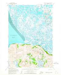
 2020 Hooper Bay D-2 SW2020 Print · USGSScammon Bay and the surrounding coastal peaks of the Kusilvak Census Area are documented in this recent survey of the Bering Sea shoreline. Researchers can trace the village layout near Scammon Bay Airport, find the Scammon Bay Cem, and locate the Kun River delta.
End of results
Showing maps 1-5 of 5
Frequently asked questions
- What are the different types of historical maps available for Scammon Bay?
- What is the oldest map of Scammon Bay?
- Where can I purchase historical maps of Scammon Bay for my home or office?
- Where can I download high-res historical maps of Scammon Bay?
- Are there historical topographic maps available for Scammon Bay?
- Is there historical aerial imagery available for Scammon Bay?
- Where are historical maps of Scammon Bay sourced from?