Old Maps of Shaktoolik, Alaska for Genealogy
Trace your family roots with 6 historic maps of Shaktoolik. These high-res maps reveal old neighborhoods, homesites, landmarks, and streets — helping you uncover where your ancestors lived and how the area evolved over time.
- Explore historic neighborhoods: Identify where your relatives may have lived in the 1800s or 1900s.
- Compare maps over time: Trace the changes in streets, buildings, and landmarks for multi-generational research.
- Perfect for genealogy & ancestry research: Used by family historians and researchers to map out lineage and migration.
These maps are an incredible resource for exploring your personal connection to Shaktoolik's past.
Shaktoolik, AK maps
(6)- 1948 Map of Norton Bay, 1954 Print
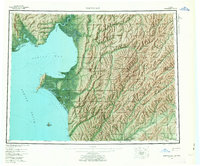
 1948 Norton Bay1954 Print · USGSThe eastern shores of Norton Sound are captured here during the late 1940s, highlighting the coastal reservations and inland mountain trails. Trace the old travel routes between Isaac Roadhouse, Egavik, and remote outposts like Old Woman Cabin.2 unique versions available
 - 1950 Map of Norton Bay B-5, 1956 Print
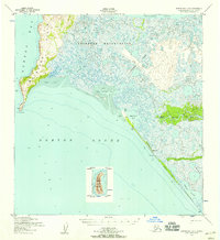 1950 Norton Bay B-51956 Print · USGSCoastal life on the shores of Norton Sound is documented here at mid-century, just as the region's traditional patterns met modern infrastructure. Genealogists and historians can trace the original location of Shaktoolik, the Winter Trail, and the sprawling Reindeer Reservation.3 unique versions available
 - 1951 Map of Norton Bay
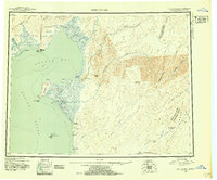
 1951 Norton Bay1951 Print · USGSThe Norton Sound coastline and Kaltag Mountains appear here during the early fifties, documenting a land of vital trail shelters and river corridors. Genealogists and historians can trace the remote network of outposts like Shaktolik Roadhouse, Kwik, and Old Woman Cabin.2 unique versions available
 - 1955 Map of Norton Bay, 1963 Print
 1955 Norton Bay1963 Print · USGSCoastal life and inland wilderness meet along the Bering Sea in the mid-1950s. Trace old travel routes like the Portage and Trail through the Reindeer Reservation to historic stops like Isaacs Roadhouse and Old Woman Cabin.4 unique versions available
 - 2014 Map of Norton Bay B-5 SE, 2014 Print
 2014 Norton Bay B-5 SE2014 Print · USGSThe village of Shaktoolik is documented here along the Norton Sound coast during the early 2010s. Researchers can trace the layout of Shaktoolik and its essential Shaktoolik Airport tucked between the Tagoomenik River and the sea.
 - 2014 Map of Norton Bay B-5 NE, 2014 Print
 2014 Norton Bay B-5 NE2014 Print · USGSCoastal Alaska meets the Bering Sea in this 2014 survey of the Norton Bay region. Researchers can trace the intricate shoreline and inland drainage patterns of Shaktoolik Bay, Reindeer Cove, and Second Cr across this wetland landscape.
End of results
Showing maps 1-6 of 6
Frequently asked questions
- What are the different types of historical maps available for Shaktoolik?
- What is the oldest map of Shaktoolik?
- Where can I purchase historical maps of Shaktoolik for my home or office?
- Where can I download high-res historical maps of Shaktoolik?
- Are there historical topographic maps available for Shaktoolik?
- Is there historical aerial imagery available for Shaktoolik?
- Where are historical maps of Shaktoolik sourced from?