Old Maps of Sleetmute, Alaska
Explore 4 old maps of Sleetmute, spanning from 1950 to today. These high-resolution historic maps reveal how streets, neighborhoods, landmarks, and natural features evolved over time — perfect for genealogy, metal detecting, research, and local history exploration.
What you can do with these maps:
- See how Sleetmute changed over time: Compare historical maps to modern-day views to trace roads, homesites, rail lines & more.
- View detailed metadata: Each map includes creators, publishers, year, scale, and archive source.
- Overlay maps with satellite & LiDAR: Visualize the past alongside modern tools to explore terrain & human change.
- Trusted historical sources: Maps sourced from the USGS, Library of Congress, and other archives.
- Access maps your way: View online, download high-res files, or order prints for personal or research use.
Start exploring old maps of Sleetmute to uncover forgotten places, hidden landmarks, and the deep history beneath your feet.
Sleetmute, AK maps
(4)- 1950 Map of Sleetmute
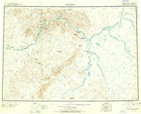 1950 Sleetmute1950 Print · USGSThe Kuskokwim River corridor in the 1950s was a hub of interior Alaskan trade, where commerce relied on seasonal waterways and winter trails. Researchers can trace historic river outposts like Mellicks Trading Post, the Iditarod Winter Trail, and the remnants of Kolmakof Fort (Ruins).2 unique versions available
 - 1954 Map of Sleetmute C-4, 1961 Print
 1954 Sleetmute C-41961 Print · USGSThe mid-century Kuskokwim River corridor comes to life in this survey of the Alaskan interior during the 1950s. Genealogists and historians can trace the foundations of Sleetmute and Mellicks Trading Post, along with essential regional landmarks like the Airstrip and local Cem.2 unique versions available
 - 1954 Map of Sleetmute, 1967 Print
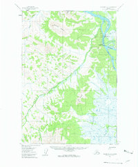
 1954 Sleetmute1967 Print · USGSThe Kuskokwim River corridor in the mid-1950s reveals a network of trade sites and riverside villages between the Horn and Chuilnuk Mountains. Genealogists and researchers can locate remote outposts like Mellicks Trading Post, Red Devil, and the former Kolmakof village site.2 unique versions available
 - 2019 Map of Sleetmute C-4 NE, 2019 Print
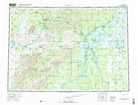
 2019 Sleetmute C-4 NE2019 Print · USGSThe Kuskokwim and Holitna rivers meet in the Alaskan interior during this 2019 survey of the remote Bethel region. Genealogists and historians can trace the community layout of Sleetmute, the location of Mellicks Trading Post, and local landmarks like Cemetery Rd.
End of results
Showing maps 1-4 of 4
Frequently asked questions
- What are the different types of historical maps available for Sleetmute?
- What is the oldest map of Sleetmute?
- Where can I purchase historical maps of Sleetmute for my home or office?
- Where can I download high-res historical maps of Sleetmute?
- Are there historical topographic maps available for Sleetmute?
- Is there historical aerial imagery available for Sleetmute?
- Where are historical maps of Sleetmute sourced from?