
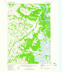
1954 Map of Sleetmute C-4
USGS Topo · Published 1961About this map
Kuskokwim River serves as the primary artery for travel and trade in this mid-century Alaskan interior, where the Sleetmute settlement is anchored at the river's bend. The presence of Mellicks Trading Post and an adjacent Airstrip underscores the reliance on bush aviation and river transport for supply lines. To the south, the confluence with the Holitna River opens into a landscape marked by substantial topographic markers like Barometer Mountain and Red Mountain. The map detail includes a Cem and evidence of seasonal travel routes such as a Winter Trail and Tractor Trail, reflecting the area's logistical challenges and remote network of creeks including Vreeland Creek and Red Devil Creek. These labels provide a window into the infrastructure of Alaskan river life before widespread modern development.
Find a feature on this map
18 named features on this map. Tap any name to fly to it.
Don’t see what you’re looking for? This feature index may not catch every label — zoom into the map to look around manually.
Map Details
Editions of this 1954 Sleetmute C-4 Map
2 editions found
Other maps of this area

1950 · Sleetmute
USGS Topo · 1:250,000

1954 · Sleetmute D-5
USGS Topo · 1:63,360

1954 · Sleetmute D-4
USGS Topo · 1:63,360

1954 · Sleetmute D-3
USGS Topo · 1:63,360

1954 · Sleetmute C-3
USGS Topo · 1:63,360

1954 · Sleetmute C-5
USGS Topo · 1:63,360

1954 · Sleetmute
USGS Topo · 1:250,000

1954 · Sleetmute B-3
USGS Topo · 1:63,360

1954 · Sleetmute B-5
USGS Topo · 1:63,360

1954 · Sleetmute B-4
USGS Topo · 1:63,360