
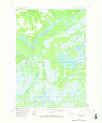
1954 Map of Sleetmute C-3
USGS Topo · Published 1961About this map
The Kuskokwim River dominates this landscape, its wide channel and intricate side channels like Barge Slough carving through the wet interior of Alaska. This mid-century survey reveals a wilderness defined by its water routes and seasonal paths, where a Winter Trail and Tractor Trail provided the primary means of overland movement across the marshy terrain. Small human imprints are scattered along the riverbanks in the form of a Cabin, several Cabins, and a Cache, indicating the traditional subsistence and trapping patterns of the region.
Find a feature on this map
17 named features on this map. Tap any name to fly to it.
Don’t see what you’re looking for? This feature index may not catch every label — zoom into the map to look around manually.
Map Details
Editions of this 1954 Sleetmute C-3 Map
2 editions found
Other maps of this area

1950 · Sleetmute
USGS Topo · 1:250,000

1954 · Sleetmute C-4
USGS Topo · 1:63,360

1954 · Sleetmute D-4
USGS Topo · 1:63,360

1954 · Sleetmute D-3
USGS Topo · 1:63,360

1954 · Sleetmute C-2
USGS Topo · 1:63,360

1954 · Sleetmute D-2
USGS Topo · 1:63,360

1954 · Sleetmute
USGS Topo · 1:250,000

1954 · Sleetmute B-2
USGS Topo · 1:63,360

1954 · Sleetmute B-3
USGS Topo · 1:63,360

1954 · Sleetmute B-4
USGS Topo · 1:63,360