
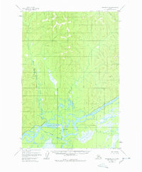
1954 Map of Sleetmute D-2
USGS Topo · Published 1961About this map
The Kuskokwim River dominates this interior Alaska landscape, weaving through a complex network of wetlands and sloughs. Surveyed in the early 1950s, the map reveals the intricate hydrology where the Stony River meets the main channel, including the Stony River Cutoff. This area reflects a wilderness defined by its waterways, providing a look at the region before significant modern development. Sparse human presence is marked only by isolated Cabins and a single Cabin along the riverbanks, likely serving as seasonal camps for hunting or trapping. The terrain rises north of the floodplains toward Moose Creek, punctuated by the geodetic marker VABM Kusk 958. The map documents the shifting nature of these glacial rivers, showing the bars and islands that dictate travel in the Alaskan interior.
Find a feature on this map
8 named features on this map. Tap any name to fly to it.
Don’t see what you’re looking for? This feature index may not catch every label — zoom into the map to look around manually.
Map Details
Editions of this 1954 Sleetmute D-2 Map
2 editions found
Other maps of this area

1950 · Sleetmute
USGS Topo · 1:250,000

1951 · Iditarod
USGS Topo · 1:250,000

1954 · Sleetmute D-1
USGS Topo · 1:63,360

1954 · Sleetmute D-3
USGS Topo · 1:63,360

1954 · Sleetmute C-2
USGS Topo · 1:63,360

1954 · Sleetmute C-1
USGS Topo · 1:63,360

1954 · Sleetmute C-3
USGS Topo · 1:63,360

1954 · Iditarod A-1
USGS Topo · 1:63,360

1954 · Iditarod A-2
USGS Topo · 1:63,360

1954 · Sleetmute
USGS Topo · 1:250,000