
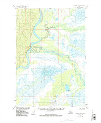
1954 Map of Sleetmute D-1
USGS Topo · Published 1961About this map
The Kuskokwim River dominates this mid-century Alaskan landscape, cutting a wide, meandering path through a region defined by extensive marshlands and braided waterways. This 1954 field-annotated survey reveals a wilderness mostly untouched by permanent infrastructure, with only a lone Cabin situated along the western bank of the river providing evidence of human residency or seasonal trapping. The hydrology is complex, with the Tatlawiksuk River and the Swift River feeding into the main Kuskokwim channel through a network of smaller sloughs and wetlands. Higher elevations are marked by geodetic control points such as VABM Swift 424 and VABM 364 Boulder, which served as critical landmarks for the photogrammetric mapping of this remote interior territory. The map captures the Kuskokwim before any modern development, reflecting the era's reliance on aerial photography and limited field checking to document the vast, shifting river deltas of the Bethel region.
Find a feature on this map
6 named features on this map. Tap any name to fly to it.
Don’t see what you’re looking for? This feature index may not catch every label — zoom into the map to look around manually.
Map Details
Editions of this 1954 Sleetmute D-1 Map
2 editions found
Other maps of this area

1949 · McGrath
USGS Topo · 1:250,000

1950 · Sleetmute
USGS Topo · 1:250,000

1950 · McGrath
USGS Topo · 1:250,000

1951 · Lime Hills
USGS Topo · 1:250,000

1951 · Iditarod
USGS Topo · 1:250,000

1954 · Sleetmute C-2
USGS Topo · 1:63,360

1954 · Sleetmute C-1
USGS Topo · 1:63,360

1954 · Sleetmute D-2
USGS Topo · 1:63,360

1954 · Iditarod A-1
USGS Topo · 1:63,360
1954 · McGrath A-6
USGS Topo · 1:63,360