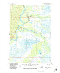
1954 Map of Sleetmute D-1
USGS Topo · Published 1987About this map
The Kuskokwim River dominates this mid-century Alaskan landscape, cutting through a remote territory defined by its complex river systems and extensive wetlands. Photogrammetric methods from 1953 aerial photography reveal the intricate, winding course of the Tatlawiksuk River as it meanders toward its confluence, alongside the Swift River to the east. Human presence is sparse, marked only by a solitary Cabin located on the western bank of the Kuskokwim, signifying the isolation of this interior region before modern development. Survey markers such as Vabm Swift 424 and Vabm 364 Boulder provide the few fixed reference points in a terrain largely characterized by unsurveyed land lines and seasonal swamps.
Find a feature on this map
6 named features on this map. Tap any name to fly to it.
Don’t see what you’re looking for? This feature index may not catch every label — zoom into the map to look around manually.
Map Details
Editions of this 1954 Sleetmute D-1 Map
2 editions found
Other maps of this area

1949 · McGrath
USGS Topo · 1:250,000

1950 · Sleetmute
USGS Topo · 1:250,000

1950 · McGrath
USGS Topo · 1:250,000

1951 · Lime Hills
USGS Topo · 1:250,000

1951 · Iditarod
USGS Topo · 1:250,000

1954 · Sleetmute D-1
USGS Topo · 1:63,360

1954 · Sleetmute C-2
USGS Topo · 1:63,360

1954 · Sleetmute C-1
USGS Topo · 1:63,360

1954 · Sleetmute D-2
USGS Topo · 1:63,360

1954 · Iditarod A-1
USGS Topo · 1:63,360