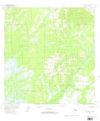
1954 Map of McGrath A-6
USGS Topo · Published 1964About this map
The Tatlawiksuk River winds through this interior landscape as it appeared in the mid-1950s. Surveyed during an era of expanding aerial photogrammetry, this topographical study by the Geological Survey documents a region defined by complex drainage patterns and low-lying wetlands. The presence of Shifting Sand along the river banks indicates a dynamic fluvial environment where watercourses frequently alter their paths across the alluvial plains. Unlike many contemporary maps of more developed regions, this 1954 sheet reveals a territory entirely devoid of roads or trails, providing a primary source for understanding the pristine hydrological state of the Yukon-Koyukuk region before any modern infrastructure or human impact.
Find a feature on this map
2 named features on this map. Tap any name to fly to it.
Don’t see what you’re looking for? This feature index may not catch every label — zoom into the map to look around manually.
Map Details
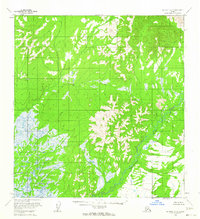
Editions of this 1954 McGrath A-6 Map
2 editions found
Other maps of this area

1949 · McGrath
USGS Topo · 1:250,000

1950 · Sleetmute
USGS Topo · 1:250,000

1950 · McGrath
USGS Topo · 1:250,000

1951 · Lime Hills
USGS Topo · 1:250,000

1951 · Iditarod
USGS Topo · 1:250,000

1954 · Sleetmute D-1
USGS Topo · 1:63,360

1954 · Iditarod B-1
USGS Topo · 1:63,360

1954 · Iditarod A-1
USGS Topo · 1:63,360

1954 · McGrath B-6
USGS Topo · 1:63,360
1954 · Lime Hills D-7
USGS Topo · 1:63,360