
1954 Map of Iditarod B-1
USGS Topo · Published 1962About this map
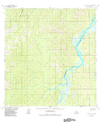
The Kuskokwim River winds through the eastern portion of this territory, serving as the dominant geographic feature in an area defined by extensive river systems and high peaks. Along its banks, a solitary Cabin indicates a human presence in this remote interior landscape. The drainage patterns are defined by the Black Mountain River flowing from the north and the Nunsatuk River entering from the southwest. Significant elevation points used for surveying include VABM 2073 Hishie and VABM 1138 Nunsa, which overlook the surrounding valley. The prominent Black Mountain rises in the northwest corner, anchoring the high ground above the river basins. This map reflects the state of the Alaskan interior in the early 1950s, documenting the natural waterways and survey markers before significant modern development altered the region.
Find a feature on this map
7 named features on this map. Tap any name to fly to it.
Don’t see what you’re looking for? This feature index may not catch every label — zoom into the map to look around manually.
Map Details
Editions of this 1954 Iditarod B-1 Map
2 editions found
Other maps of this area

1949 · McGrath
USGS Topo · 1:250,000

1950 · McGrath
USGS Topo · 1:250,000

1951 · Iditarod
USGS Topo · 1:250,000

1954 · Iditarod A-1
USGS Topo · 1:63,360

1954 · McGrath B-6
USGS Topo · 1:63,360

1954 · McGrath C-6
USGS Topo · 1:63,360

1954 · Iditarod B-2
USGS Topo · 1:63,360

1954 · Iditarod A-2
USGS Topo · 1:63,360
1954 · McGrath A-6
USGS Topo · 1:63,360

1954 · Iditarod C-2
USGS Topo · 1:63,360