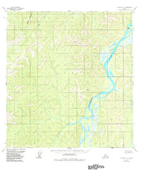
1954 Map of Iditarod B-1
USGS Topo · Published 1984About this map
The Kuskokwim River serves as the central artery for this remote Alaskan landscape, winding through a complex network of wetlands and tributaries. In the mid-1950s, human activity in this region was sparse, anchored by isolated outposts like Deacons Landing and a single riverside Cabin. The topography is defined by the significant rise of Black Mountain in the northwest and prominent survey markers such as VABM 2073 Hibla and VABM 1138 Nunsa. These points, along with the Black River and Nunsatuk River, illustrate a wilderness where transportation was dictated entirely by water and seasonal terrain. The lack of roads or established trails highlights the reliance on river access for the few established landings and remote dwellings present at the time of the survey.
Find a feature on this map
8 named features on this map. Tap any name to fly to it.
Don’t see what you’re looking for? This feature index may not catch every label — zoom into the map to look around manually.
Map Details
Editions of this 1954 Iditarod B-1 Map
2 editions found
Other maps of this area

1949 · McGrath
USGS Topo · 1:250,000

1950 · McGrath
USGS Topo · 1:250,000

1951 · Iditarod
USGS Topo · 1:250,000

1954 · Iditarod B-1
USGS Topo · 1:63,360

1954 · Iditarod A-1
USGS Topo · 1:63,360

1954 · McGrath B-6
USGS Topo · 1:63,360

1954 · McGrath C-6
USGS Topo · 1:63,360

1954 · Iditarod B-2
USGS Topo · 1:63,360

1954 · Iditarod A-2
USGS Topo · 1:63,360
1954 · McGrath A-6
USGS Topo · 1:63,360