
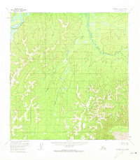
1954 Map of McGrath B-6
USGS Topo · Published 1963About this map
The Kuskokwim River winds through the northwest corner of this interior landscape, which was documented through aerial photography in the early 1950s. This territory is defined by its complex drainage systems, including the Selatna River and the First Fork, showing a wilderness as it appeared before modern infrastructure development. Surveyors established vertical control points at high elevations such as Vabm Heart, Vabm Upatut, and Vabm Salak, providing foundational topographic data for the region. The map reflects the early work of the Geological Survey and the Bureau of Land Management in predetermining unsurveyed and unmarked land lines across the Seward Meridian.
Find a feature on this map
6 named features on this map. Tap any name to fly to it.
Don’t see what you’re looking for? This feature index may not catch every label — zoom into the map to look around manually.
Map Details
Editions of this 1954 McGrath B-6 Map
2 editions found
Other maps of this area

1949 · McGrath
USGS Topo · 1:250,000

1950 · McGrath
USGS Topo · 1:250,000

1951 · Iditarod
USGS Topo · 1:250,000

1954 · Iditarod B-1
USGS Topo · 1:63,360

1954 · Iditarod A-1
USGS Topo · 1:63,360

1954 · McGrath C-6
USGS Topo · 1:63,360

1954 · McGrath B-5
USGS Topo · 1:63,360
1954 · McGrath A-5
USGS Topo · 1:63,360
1954 · McGrath A-6
USGS Topo · 1:63,360
1955 · McGrath C-5
USGS Topo · 1:63,360