
1954 Map of McGrath B-5
USGS Topo · Published 1964About this map
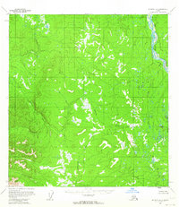
Big River defines the eastern boundary of this mid-century Alaskan interior landscape, where the Kuskokwim River drainage system branches into a network of winding tributaries. Surveyed via aerial photography in the early 1950s, the terrain is characterized by the meandering paths of the Selatna River and the Tatlawiksuk River, which cut through a complex system of marshes and low-lying elevations. The absence of roads or established trails on this sheet reflects the wilderness state of the Yukon-Koyukuk region during this era, when transportation was primarily reliant on these seasonal waterways. The map captures the natural drainage patterns and topographical contours of a territory managed by the Bureau of Land Management, preserved here at the scale of 1:63,360.
Find a feature on this map
3 named features on this map. Tap any name to fly to it.
Don’t see what you’re looking for? This feature index may not catch every label — zoom into the map to look around manually.
Map Details
Editions of this 1954 McGrath B-5 Map
2 editions found
Other maps of this area

1949 · McGrath
USGS Topo · 1:250,000

1950 · McGrath
USGS Topo · 1:250,000

1953 · McGrath C-4
USGS Topo · 1:63,360

1954 · McGrath B-4
USGS Topo · 1:63,360

1954 · McGrath B-6
USGS Topo · 1:63,360

1954 · McGrath A-4
USGS Topo · 1:63,360

1954 · McGrath C-6
USGS Topo · 1:63,360
1954 · McGrath A-5
USGS Topo · 1:63,360
1954 · McGrath A-6
USGS Topo · 1:63,360
1955 · McGrath C-5
USGS Topo · 1:63,360