
1954 Map of McGrath A-4
USGS Topo · Published 1963About this map
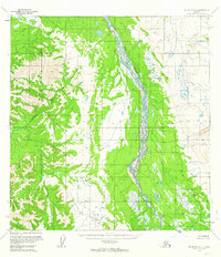
Big River dominates this interior landscape, weaving its complex braided channels across a broad valley floor. Surveyed during the mid-1950s using photogrammetric methods from 1953 and 1954 aerial photography, the map reveals an environment defined by its natural drainage patterns and the absence of established infrastructure. The wide alluvial plain of the Big River is contrasted by the rising terrain to the west where the Cheeneetnuk River begins its course. This document is particularly significant for its depiction of the Seward Meridian land lines, which were predetermined by the Bureau of Land Management but remained unsurveyed and unmarked on the ground at the time of publication. The intricate network of wetlands, ponds, and shifting river bars provides a detailed look at the hydrology of the McGrath region before modern development or environmental changes.
Find a feature on this map
2 named features on this map. Tap any name to fly to it.
Don’t see what you’re looking for? This feature index may not catch every label — zoom into the map to look around manually.
Map Details
Editions of this 1954 McGrath A-4 Map
2 editions found
Other maps of this area

1949 · McGrath
USGS Topo · 1:250,000

1950 · McGrath
USGS Topo · 1:250,000

1951 · Lime Hills
USGS Topo · 1:250,000

1954 · McGrath B-4
USGS Topo · 1:63,360

1954 · Lime Hills D-6
USGS Topo · 1:63,360

1954 · McGrath B-5
USGS Topo · 1:63,360

1954 · Lime Hills D-5
USGS Topo · 1:63,360
1954 · McGrath A-5
USGS Topo · 1:63,360

1958 · McGrath A-3
USGS Topo · 1:63,360
1958 · McGrath B-3
USGS Topo · 1:63,360