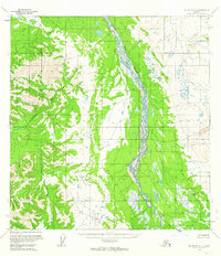
1954 Map of McGrath A-4
USGS Topo · Published 1963About this map
Big River dominates this mid-century topographic record, winding northward through an intricate network of braided channels and wetlands. This survey, based on aerial photography from 1953 and 1954, reveals a landscape defined entirely by its hydrology and terrain, notably absent of any established roads or human settlements. The Cheeneetnuk River flows from the western uplands, contributing to the complex drainage patterns of the Yukon-Koyukuk region. The map captures the raw state of the Alaskan interior at a time when mapping relied on photogrammetric methods to document remote river systems and the vast topographic contours of the surrounding high ground. It serves as a definitive baseline for the natural movement of these waterways before later environmental shifts.
Find a feature on this map
8 named features on this map. Tap any name to fly to it.
Don’t see what you’re looking for? This feature index may not catch every label — zoom into the map to look around manually.
Map Details
Editions of this 1954 McGrath A-4 Map
2 editions found
Other maps of this area

1949 · McGrath
USGS Topo · 1:250,000

1950 · McGrath
USGS Topo · 1:250,000

1951 · Lime Hills
USGS Topo · 1:250,000

1954 · McGrath B-4
USGS Topo · 1:63,360

1954 · McGrath A-4
USGS Topo · 1:63,360

1954 · Lime Hills D-6
USGS Topo · 1:63,360

1954 · McGrath B-5
USGS Topo · 1:63,360

1954 · Lime Hills D-5
USGS Topo · 1:63,360
1954 · McGrath A-5
USGS Topo · 1:63,360

1958 · McGrath A-3
USGS Topo · 1:63,360