
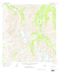
1958 Map of McGrath A-3
USGS Topo · Published 1964About this map
The Middle Fork Kuskokwim River snakes through this Alaskan landscape, defining a complex drainage system within the Seward Meridian. This 1958 field-annotated survey reveals a wilderness shaped by the Trimokish Hills and the convergence of several major waterways. The Windy Fork Middle Fork Kuskokwim River and the Big Fork River cut deep valleys between high ridges, illustrating the primary drainage patterns of the Kuskokwim Basin. With no roads or trails recorded, the map emphasizes the natural geography, showing the North Fork and the intricate glacial and alluvial features common to this interior region. It captures the area as it was mapped by photogrammetric methods in the mid-1950s, serving as a foundational record of the topography before later changes in the territory.
Find a feature on this map
11 named features on this map. Tap any name to fly to it.
Don’t see what you’re looking for? This feature index may not catch every label — zoom into the map to look around manually.
Map Details
Editions of this 1958 McGrath A-3 Map
2 editions found
Other maps of this area

1949 · McGrath
USGS Topo · 1:250,000

1950 · McGrath
USGS Topo · 1:250,000

1951 · Lime Hills
USGS Topo · 1:250,000

1954 · McGrath B-4
USGS Topo · 1:63,360

1954 · McGrath A-4
USGS Topo · 1:63,360

1954 · Lime Hills D-5
USGS Topo · 1:63,360

1958 · McGrath A-2
USGS Topo · 1:63,360

1958 · McGrath B-2
USGS Topo · 1:63,360
1958 · McGrath B-3
USGS Topo · 1:63,360

1958 · Lime Hills D-3
USGS Topo · 1:63,360