
1954 Map of McGrath B-4
USGS Topo · Published 1962About this map
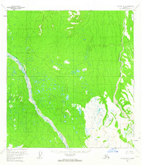
Lone Mountain stands as a primary landmark in this interior Alaskan wilderness, rising above a vast network of wetlands and shifting watercourses. The landscape is defined by the braided path of the Big River, which winds northwest across the terrain, and the Middle Fork Kuskokwim River situated along the eastern edge of the quadrangle. Produced from 1953 aerial photography and field-annotated in 1954, this survey captures the region before any established roads or permanent trails were documented by the Department of the Interior. The map illustrates a complex hydrology of unnamed ponds and marshes, highlighting the intricate drainage patterns characteristic of the Yukon-Koyukuk region during the mid-20th century.
Find a feature on this map
3 named features on this map. Tap any name to fly to it.
Don’t see what you’re looking for? This feature index may not catch every label — zoom into the map to look around manually.
Map Details
Editions of this 1954 McGrath B-4 Map
2 editions found
Other maps of this area

1949 · McGrath
USGS Topo · 1:250,000

1950 · McGrath
USGS Topo · 1:250,000

1953 · McGrath C-4
USGS Topo · 1:63,360

1954 · McGrath A-4
USGS Topo · 1:63,360

1954 · McGrath C-3
USGS Topo · 1:63,360

1954 · McGrath B-5
USGS Topo · 1:63,360
1954 · McGrath A-5
USGS Topo · 1:63,360
1955 · McGrath C-5
USGS Topo · 1:63,360

1958 · McGrath A-3
USGS Topo · 1:63,360
1958 · McGrath B-3
USGS Topo · 1:63,360