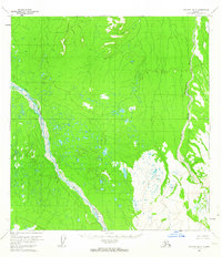
1954 Map of McGrath B-4
USGS Topo · Published 1963About this map
Lone Mountain dominates the northern terrain of this remote Interior Alaska landscape, rising above a complex network of wetlands and braided waterways. The hydrology of the region is defined by the expansive, shifting channels of the Big River in the west and the Middle Fork Kuskokwim River to the east. These glacial rivers carve through a mosaic of small lakes and marshy lowlands, illustrating the untamed character of the Yukon-Koyukuk region in the mid-1950s. Surveyed via photogrammetric methods from 1953 aerial photography, the map reflects a wilderness devoid of roads or permanent settlements, where the land was shaped almost entirely by seasonal water flow and the geological prominence of isolated peaks like Lone Mountain.
Find a feature on this map
3 named features on this map. Tap any name to fly to it.
Don’t see what you’re looking for? This feature index may not catch every label — zoom into the map to look around manually.
Map Details
Editions of this 1954 McGrath B-4 Map
2 editions found
Other maps of this area

1949 · McGrath
USGS Topo · 1:250,000

1950 · McGrath
USGS Topo · 1:250,000

1953 · McGrath C-4
USGS Topo · 1:63,360

1954 · McGrath B-4
USGS Topo · 1:63,360

1954 · McGrath A-4
USGS Topo · 1:63,360

1954 · McGrath C-3
USGS Topo · 1:63,360

1954 · McGrath B-5
USGS Topo · 1:63,360
1954 · McGrath A-5
USGS Topo · 1:63,360
1955 · McGrath C-5
USGS Topo · 1:63,360

1958 · McGrath A-3
USGS Topo · 1:63,360