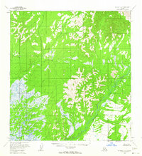
1954 Map of McGrath A-6
USGS Topo · Published 1964About this map
The Tatlawiksuk River winds through this interior landscape, which was mapped by the Geological Survey using aerial photography from the mid-1950s. The terrain is defined by a significant contrast between the high, un-wooded ridges and the expansive wet lowlands that dominate the western half of the quadrangle. In the eastern portion, the river creates complex drainage patterns near a curious landmark labeled Shifting Sand, an indication of the active alluvial processes at work in this subarctic environment. The lack of established roads or trails during this period highlights the remote character of the region. As part of the Seward Meridian, the land lines here were predetermined by the Bureau of Land Management but remained largely unsurveyed and unmarked on the ground at the time of this survey's field annotation.
Find a feature on this map
8 named features on this map. Tap any name to fly to it.
Don’t see what you’re looking for? This feature index may not catch every label — zoom into the map to look around manually.
Map Details
Editions of this 1954 McGrath A-6 Map
2 editions found
Other maps of this area

1949 · McGrath
USGS Topo · 1:250,000

1950 · Sleetmute
USGS Topo · 1:250,000

1950 · McGrath
USGS Topo · 1:250,000

1951 · Lime Hills
USGS Topo · 1:250,000

1951 · Iditarod
USGS Topo · 1:250,000

1954 · Sleetmute D-1
USGS Topo · 1:63,360

1954 · Iditarod B-1
USGS Topo · 1:63,360

1954 · Iditarod A-1
USGS Topo · 1:63,360

1954 · McGrath B-6
USGS Topo · 1:63,360
1954 · Lime Hills D-7
USGS Topo · 1:63,360