
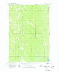
1954 Map of Sleetmute D-3
USGS Topo · Published 1961About this map
The East Fork George River and South Fork George River dominate this interior Alaskan landscape, carved into a complex network of ridges and drainage basins. A lone Tractor Trail provides the only mapped overland route through the southern half of the quadrangle, suggesting the seasonal and demanding nature of travel in this region during the mid-1950s. The topographic detail highlights prominent landmarks such as Pimple and the surveying station VABM Pimple, which served as critical navigation and reference points for early aerial photogrammetric mapping. In the far southeastern corner, the Kuskokwim River makes a brief appearance, marking the primary waterway that has historically anchored movement and life in this part of the territory. The presence of Inowak Creek further illustrates the intricate watershed system that defines this unpopulated wilderness.
Find a feature on this map
7 named features on this map. Tap any name to fly to it.
Don’t see what you’re looking for? This feature index may not catch every label — zoom into the map to look around manually.
Map Details
Editions of this 1954 Sleetmute D-3 Map
2 editions found
Other maps of this area

1950 · Sleetmute
USGS Topo · 1:250,000

1951 · Iditarod
USGS Topo · 1:250,000

1954 · Sleetmute C-4
USGS Topo · 1:63,360

1954 · Sleetmute D-4
USGS Topo · 1:63,360

1954 · Sleetmute C-2
USGS Topo · 1:63,360

1954 · Sleetmute D-2
USGS Topo · 1:63,360

1954 · Sleetmute C-3
USGS Topo · 1:63,360

1954 · Iditarod A-3
USGS Topo · 1:63,360

1954 · Iditarod A-2
USGS Topo · 1:63,360

1954 · Sleetmute
USGS Topo · 1:250,000