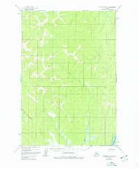
1954 Map of Sleetmute D-3
USGS Topo · Published 1977About this map
The Kiskokwim River flows through the southeastern corner of this Alaskan interior landscape, a critical waterway for navigation and transport in the Bethel region. The terrain is defined by a dense network of drainages, most notably the meandering Inowak Creek and the South Fork George River, which carve through the high ground. A solitary Tractor Trail provides a Rare overland route through the brush and wetlands, following the George River valley into the interior. This track, likely used for mineral exploration or logistical transport, represents one of the few human imprints on the mid-century landscape. Survey control in this remote area is anchored by high points such as Vabm Pimple, serving as a primary reference for the 1950s aerial photogrammetry that first mapped this wilderness.
Find a feature on this map
5 named features on this map. Tap any name to fly to it.
Don’t see what you’re looking for? This feature index may not catch every label — zoom into the map to look around manually.
Map Details
Editions of this 1954 Sleetmute D-3 Map
2 editions found
Other maps of this area

1950 · Sleetmute
USGS Topo · 1:250,000

1951 · Iditarod
USGS Topo · 1:250,000

1954 · Sleetmute C-4
USGS Topo · 1:63,360

1954 · Sleetmute D-4
USGS Topo · 1:63,360

1954 · Sleetmute D-3
USGS Topo · 1:63,360

1954 · Sleetmute C-2
USGS Topo · 1:63,360

1954 · Sleetmute D-2
USGS Topo · 1:63,360

1954 · Sleetmute C-3
USGS Topo · 1:63,360

1954 · Iditarod A-3
USGS Topo · 1:63,360

1954 · Iditarod A-2
USGS Topo · 1:63,360