
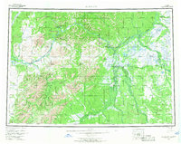
1954 Map of Sleetmute
USGS Topo · Published 1967About this map
The Kuskokwim River serves as the central artery for this mid-century Alaskan interior survey, connecting a series of remote settlements and river-dependent outposts. From Georgetown and Crooked Creek downstream to the mining-related activity at Red Devil, the map documents a landscape defined by seasonal movement and trade. Significant local history is anchored at Mellicks Trading Post and the larger settlement of Sleetmute, while the interior is navigated by a network of tractor trails and winter trails.
Find a feature on this map
74 named features on this map. Tap any name to fly to it.
Don’t see what you’re looking for? This feature index may not catch every label — zoom into the map to look around manually.
Map Details
Editions of this 1954 Sleetmute Map
2 editions found
Other maps of this area

1946 · Lake Clark
USGS Topo · 1:250,000

1947 · Russian Mission
USGS Topo · 1:250,000

1949 · McGrath
USGS Topo · 1:250,000

1950 · Russian Mission
USGS Topo · 1:250,000

1950 · Sleetmute
USGS Topo · 1:250,000

1950 · McGrath
USGS Topo · 1:250,000

1950 · Bethel
USGS Topo · 1:250,000

1950 · Taylor Mountains
USGS Topo · 1:250,000

1951 · Lake Clark
USGS Topo · 1:250,000

1951 · Taylor Mountains
USGS Topo · 1:250,000