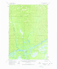
1954 Map of Sleetmute D-2
USGS Topo · Published 1978About this map
Stony River serves as a central waypoint in this 1950s interior landscape, where the confluence with the mighty Kuskokwim River dictates the pattern of human presence. The map documents a sparsely settled region where a Landing Strip and a cluster of Cabins signify the primary infrastructure for travel and shelter. This area, surveyed by the Geological Survey via aerial photography from 1953, reveals a complex network of waterways including the Stony River Cutoff and the meandering Moose Creek to the north. These features illustrate the essential reliance on river navigation and small-craft aviation in the Bethel region before modern development. Notable terrain markers like VABM Kusk 958 provide fixed points for navigation across the wetlands and forested reaches that dominate the quadrangle.
Find a feature on this map
9 named features on this map. Tap any name to fly to it.
Don’t see what you’re looking for? This feature index may not catch every label — zoom into the map to look around manually.
Map Details
Editions of this 1954 Sleetmute D-2 Map
2 editions found
Other maps of this area

1950 · Sleetmute
USGS Topo · 1:250,000

1951 · Iditarod
USGS Topo · 1:250,000

1954 · Sleetmute D-1
USGS Topo · 1:63,360

1954 · Sleetmute D-3
USGS Topo · 1:63,360

1954 · Sleetmute C-2
USGS Topo · 1:63,360

1954 · Sleetmute C-1
USGS Topo · 1:63,360

1954 · Sleetmute D-2
USGS Topo · 1:63,360

1954 · Sleetmute C-3
USGS Topo · 1:63,360

1954 · Iditarod A-1
USGS Topo · 1:63,360

1954 · Iditarod A-2
USGS Topo · 1:63,360