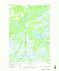
1954 Map of Sleetmute C-3
USGS Topo · Published 1974About this map
The Kuskokwim River serves as the central artery for this interior Alaskan landscape, where the convergence of several major waterways dictated travel and survival in the mid-1950s. The map illustrates a complex network of wetlands and seasonal watercourses, including the Holitna River and Hoholitna River, which wind through vast swampy lowlands. Human presence is marked by isolated caches and a single cabin near the northern bend of the Kuskokwim, signifying the temporary and seasonal nature of habitation in this region. Overland movement is limited to specialized routes such as a tractor path and a winter trail, reflecting the area's reliance on frozen ground or river travel for transit. Distinctive landmarks like Beaverhouse Hill and Big Lake provide essential navigation points for hunters and trappers navigating the shifting channels of Johnny Slough and Barge Slough.
Find a feature on this map
19 named features on this map. Tap any name to fly to it.
Don’t see what you’re looking for? This feature index may not catch every label — zoom into the map to look around manually.
Map Details
Editions of this 1954 Sleetmute C-3 Map
2 editions found
Other maps of this area

1950 · Sleetmute
USGS Topo · 1:250,000

1954 · Sleetmute C-4
USGS Topo · 1:63,360

1954 · Sleetmute D-4
USGS Topo · 1:63,360

1954 · Sleetmute D-3
USGS Topo · 1:63,360

1954 · Sleetmute C-2
USGS Topo · 1:63,360

1954 · Sleetmute D-2
USGS Topo · 1:63,360

1954 · Sleetmute C-3
USGS Topo · 1:63,360

1954 · Sleetmute
USGS Topo · 1:250,000

1954 · Sleetmute B-2
USGS Topo · 1:63,360

1954 · Sleetmute B-3
USGS Topo · 1:63,360