
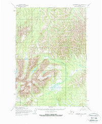
1954 Map of Sleetmute B-5
USGS Topo · Published 1968About this map
The Chuilnuk Mountains dominate the southwestern portion of this mid-century topographic study, their high ridgelines rising above a landscape defined by glacial activity and drainage networks. Derived from aerial photography taken in 1953 and 1955, the map represents a period when this part of Alaska was being systematically documented by the Army Map Service and the Geological Survey using photogrammetric methods. The intricate meandering of the Chuilnuk River as it winds through the lower elevations highlights the complex hydraulic patterns of the region, while the headwaters of Chineekluk Creek and Portage Creek drain the western slopes. This survey provides a baseline of the land before significant modern changes, documenting unsurveyed and unmarked locations pre-determined by the Bureau of Land Management for regional administration.
Find a feature on this map
4 named features on this map. Tap any name to fly to it.
Don’t see what you’re looking for? This feature index may not catch every label — zoom into the map to look around manually.
Map Details
Editions of this 1954 Sleetmute B-5 Map
2 editions found
Other maps of this area

1950 · Sleetmute
USGS Topo · 1:250,000

1954 · Sleetmute C-4
USGS Topo · 1:63,360

1954 · Sleetmute C-6
USGS Topo · 1:63,360

1954 · Sleetmute C-5
USGS Topo · 1:63,360

1954 · Sleetmute
USGS Topo · 1:250,000

1954 · Sleetmute A-5
USGS Topo · 1:63,360

1954 · Sleetmute B-4
USGS Topo · 1:63,360
1954 · Sleetmute A-4
USGS Topo · 1:63,360

1954 · Sleetmute A-6
USGS Topo · 1:63,360

1954 · Sleetmute B-6
USGS Topo · 1:63,360