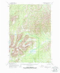
1954 Map of Sleetmute B-5
USGS Topo · Published 1968About this map
The Chulnuk Mountains dominate this 1950s landscape in southwest Alaska, forming a massive watershed that defines the drainage patterns of the region. This survey, compiled from aerial photography taken in 1953 and 1955, illustrates an era of remote wilderness mapping before the establishment of modern infrastructure. The Chuilnuk River and its tributary, Chuilnuk Creek, wind through the rugged terrain, while Portage Creek cuts across the southern portion of the quadrangle. The lack of named human settlements or roads on the map highlights the area's isolation during the mid-century, where geographical features served as the primary landmarks for navigation and land management by the Bureau of Land Management.
Find a feature on this map
4 named features on this map. Tap any name to fly to it.
Don’t see what you’re looking for? This feature index may not catch every label — zoom into the map to look around manually.
Map Details
Editions of this 1954 Sleetmute B-5 Map
2 editions found
Other maps of this area

1950 · Sleetmute
USGS Topo · 1:250,000

1954 · Sleetmute C-4
USGS Topo · 1:63,360

1954 · Sleetmute C-6
USGS Topo · 1:63,360

1954 · Sleetmute C-5
USGS Topo · 1:63,360

1954 · Sleetmute
USGS Topo · 1:250,000

1954 · Sleetmute A-5
USGS Topo · 1:63,360

1954 · Sleetmute B-5
USGS Topo · 1:63,360

1954 · Sleetmute B-4
USGS Topo · 1:63,360
1954 · Sleetmute A-4
USGS Topo · 1:63,360

1954 · Sleetmute A-6
USGS Topo · 1:63,360