
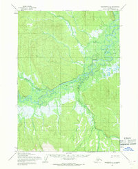
1954 Map of Sleetmute A-5
USGS Topo · Published 1968About this map
The Holitna River meanders through this interior Alaska landscape, creating a complex network of wetlands and drainage basins as it flows toward the southwest. In the mid-1950s, this area remained largely unsurveyed by ground, with land lines predetermined by the Bureau of Land Management rather than marked in the field. Small riverside settlements like Nogamut and Nugamut are documented along the southern reaches, providing evidence of early habitation and seasonal activity in the Kuskokwim River drainage. Further north, the confluence of Portage Creek and several isolated cabins along the water suggest the area's importance for trapping or subsistence. The presence of Taylor West Base reflects the geodetic control work required to map this terrain using photogrammetric methods from aerial photography taken between 1953 and 1955. This sheet effectively preserves the spatial relationship between the river system and the Chuilnuk River to the northeast before more modern development reached the region.
Find a feature on this map
12 named features on this map. Tap any name to fly to it.
Don’t see what you’re looking for? This feature index may not catch every label — zoom into the map to look around manually.
Map Details
Editions of this 1954 Sleetmute A-5 Map
This is the sole edition of this map. No revisions or reprints were ever made.
Other maps of this area

1950 · Sleetmute
USGS Topo · 1:250,000

1950 · Taylor Mountains
USGS Topo · 1:250,000

1951 · Taylor Mountains
USGS Topo · 1:250,000

1954 · Sleetmute
USGS Topo · 1:250,000

1954 · Taylor Mountains
USGS Topo · 1:250,000

1954 · Taylor Mountains D-6
USGS Topo · 1:63,360

1954 · Sleetmute B-5
USGS Topo · 1:63,360

1954 · Taylor Mountains D-5
USGS Topo · 1:63,360

1954 · Sleetmute B-4
USGS Topo · 1:63,360
1954 · Sleetmute A-4
USGS Topo · 1:63,360