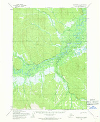
1954 Map of Sleetmute A-4
USGS Topo · Published 1968About this map
The Holitna River dominates this mid-1950s interior landscape, winding through a complex network of wetlands and forested hills. Its intricate oxbows and secondary channels reflect a drainage system largely untouched by permanent settlement, save for the presence of a Tractor Trail that cuts through the lowlands east of the main river. This single overland route serves as a crucial indicator of mid-century exploration or transport in the remote Sleetmute region. Smaller tributaries like Taylor Creek, Stevens Creek, and the Chuilnuk River feed into the Holitna, creating a mosaic of water and land that defined the interior's seasonal accessibility before more modern infrastructure arrived. The topography was meticulously captured by the Army Map Service using aerial photogrammetry from 1953 and 1955, offering a precise view of the river's path before shifting natural cycles altered these waterways.
Find a feature on this map
6 named features on this map. Tap any name to fly to it.
Don’t see what you’re looking for? This feature index may not catch every label — zoom into the map to look around manually.
Map Details
Editions of this 1954 Sleetmute A-4 Map
This is the sole edition of this map. No revisions or reprints were ever made.
Other maps of this area

1950 · Sleetmute
USGS Topo · 1:250,000

1950 · Taylor Mountains
USGS Topo · 1:250,000

1951 · Taylor Mountains
USGS Topo · 1:250,000

1954 · Sleetmute
USGS Topo · 1:250,000

1954 · Taylor Mountains
USGS Topo · 1:250,000

1954 · Sleetmute A-5
USGS Topo · 1:63,360
1954 · Taylor Mountains D-3
USGS Topo · 1:63,360

1954 · Sleetmute B-3
USGS Topo · 1:63,360

1954 · Sleetmute B-5
USGS Topo · 1:63,360

1954 · Taylor Mountains D-5
USGS Topo · 1:63,360