
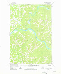
1954 Map of Sleetmute D-5
USGS Topo · Published 1961About this map
Georgetown sits at the prominent confluence where the George River meets the winding Kuskokwim River, serving as a central point of settlement in this interior landscape. This mid-century survey captures a river-dependent geography defined by isolated outposts and clearings, including several instances of a Cabin and identified Ruins along the water's edge. The presence of a Cem near the riverbank suggests a long-standing human connection to this specific stretch of the Kuskokwim. Away from the main river channels, the terrain is carved by numerous tributaries such as Steamboat Creek, California Creek, and Downey Creek. High points are meticulously marked by triangulation stations like VABM Downey 1804 and VABM Tundra 1954, providing a rare look at the established survey network in a region with no roads or trails indicated at the time of mapping.
Find a feature on this map
14 named features on this map. Tap any name to fly to it.
Don’t see what you’re looking for? This feature index may not catch every label — zoom into the map to look around manually.
Map Details
Editions of this 1954 Sleetmute D-5 Map
2 editions found
Other maps of this area

1950 · Sleetmute
USGS Topo · 1:250,000

1951 · Iditarod
USGS Topo · 1:250,000

1954 · Sleetmute C-4
USGS Topo · 1:63,360

1954 · Sleetmute D-4
USGS Topo · 1:63,360

1954 · Sleetmute D-6
USGS Topo · 1:63,360

1954 · Iditarod A-4
USGS Topo · 1:63,360

1954 · Iditarod A-3
USGS Topo · 1:63,360

1954 · Sleetmute C-6
USGS Topo · 1:63,360

1954 · Sleetmute C-5
USGS Topo · 1:63,360

1954 · Sleetmute
USGS Topo · 1:250,000